|
|
|
| UBAJARA
NATIONAL PARK THE POUSADA | HOW TO ARRIVE | CONTACT & OTHER INFO |
|
|||
 |
||||
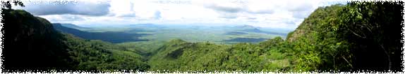
| Ubajara National Park, created in 1959 to preserve Ubajara Cave and the surrounding environment, lies in the heart of the Ibiapaba Mountains, 4 km from the town of Ubajara and only 1.5 km from the Sítio do Alemão. The small national park hosts not only its famous cave, but also several waterfalls and trails. The climate is mild and pleasant, with the rainy season lasting from January to April, when every shade of green abounds in the mountains and lowlands alike. But come October and November, the park stands out as a lush island amidst the broad expanse of dry, brown sertão, or semi-arid lowlands. In the park itself, the dominant ecosystem is "humid forest," where ferns and mosses line small creeks and large deciduous trees and palms abound. Visible animal species include two types of monkey, coati, and a host of raptors and songbirds. At lower elevations, caatinga, which means "white forest" in tupi, predominates. Cacti, cedars, and other dry-climate flora, along with snakes, lizards, and armadillos, define this semi-arid ecosystem. | ||||
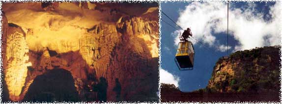
| Ubajara Cave | ||||
 |
||||
|
An impressive, Italian-built suspended cable car provides easy access to and from Ubajara Cave, along with a 6 km trail that offers a less direct, but more comprehensive, view of the park. Currently, the price to enter the park is R$4.00 and a roundtrip ticket for the cable car is R$8.00. The tram operates from 9:00 AM until 2:30 PM. Guides accompany visitors on trails and inside the cave, to ensure safety and offer explanations of cave formations, but generally speak only Portuguese. The park is closed on mondays.Inside the cave, the guided tour encounters stalagtites, stalagmites, and other interesting formations, along with bats and large cave spiders (by request!). Though the cave covers an area of approximately 1.1 kilometers, only 420 meters are illuminated and open to visitation. |
||||
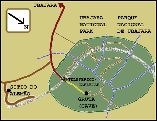
| Map of Ubajara National Park & Surrounding Area | ||||
 |
||||